Five consecutive typhoons struck the Philippines in late October and early November. Still recovering from damages brought about by Typhoon Molave (Quinta), Typhoon Goni (Rolly), Typhoon Atsani (Siony), and Typhoon Etau (Tonyo), the rain-drenched eastern and northern portions of the country endured excarbarated impacts from Typhoon Vamco (Ulysses), the fifth major storm to hit the region in just two weeks.
These typhoons left major roads impassable due to flooding and affected electrical and communication powers. Major dams in the country have reportedly worsened the flooding situations in the downstream areas of Cagayan Valley, Central Luzon, the Cordillera Administrative Region and Metro Manila.
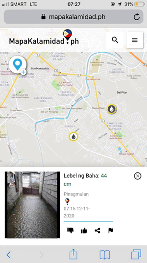
In the midst of the massive flooding situation, which paralyzed major thoroughfares and stranded thousands of Filipino commuters, hashtags #FloodPH and #RescuePH trended on social media, with people calling for help and posting information about the flood situation in their area. MapaKalamidad.ph, a recently launched disaster information sharing platform in the Philippines, is harnessing the active use of social media to support community-led risk reduction. Using AI-assisted chatbots to monitor and respond to social media posts, the platform gathers confirmed crowd-sourced reports from residents to map flooding in real-time. The platform experienced a significant increase in activity during Typhoon Ulysses as residents actively shared real-time situational updates about the flood. The free web-based map was used to support residents and disaster management units identify the areas that needed immediate response and rescue efforts. MapaKalamidad.ph was launched last September 2020 as part of the PhilAWARE Program with support from the U.S. Agency for International Development Bureau of Humanitarian Affairs (USAID BHA) in partnership with the Philippine Office of the Civil Defense (OCD), Pacific Disaster Center (PDC), and Humanitarian OpenStreetMap Team (HOT).
According to Joseph Curry, from USAID BHA, “While we depend on the government to be the authoritative source on damages and needs, we also recognize that those affected have the most up to date information and have an essential role to play. MapaKalamidad.ph adds a new dimension to data and information collection by empowering citizens to directly report hazards, critical lifelines and damages in their neighbourhoods via social media apps and mobile apps. In the true spirit of bayanihan, MapaKalamidad.ph gives us a tool that everyone can use together in disaster response, potentially connecting every barangay right to the top.”
The unpredictable behavior of the recent typhoons have highlighted the necessity for verified real-time information to support response efforts in rapidly fluctuating conditions. As storms quickly changed course and floodwaters inundated the country, netizens shared the platform has a great potential in becoming the primary information source to share real-time flood map to make more informed decisions on safety and response.
MapaKalamidad.ph is currently available to residents in Quezon City and Pampanga where residents can share flood information anonymously by sending a Facebook message to @mapakalamidad, tweeting #flood or #baha to @mapakalamidad, or sending a Telegram message to @kalamidadbot. Government emergency management agencies also monitor the map to assess the disaster situation and respond to the needs of the residents.
With La Nina conditions expected to continue, heavy rainfall is expected throughout the region over the next few months. Yayasan Peta Bencana encourages residents of the Philippines to continue sharing critical information to help their neighbors, government agencies, and emergency responders in times of disaster events.
We remind everyone to check https://mapakalamidad.ph for up-to-date flood information to stay safe!
MapaKalamidad.ph is a part of the USAID DisasterAWARE Program for ASEAN Regional and National Capacity Development for Hazard Monitoring. MapaKalamidad.ph is made possible by the support of the American People through the USAID, and through collaboration with project partners including the Pacific Disaster Center at the University of Hawaii and the Humanitarian OpenStreetMap Team; our implementing partners at the Office of Civil Defense, National Disaster Risk Reduction and Management Council, Pampanga Disaster Risk Reduction and Management Office and the Quezon City Disaster Risk Reduction and Management Office; our data partners include Twitter and Mapbox.